luminis.media Drone Real Estate Photography for Houston Private Estates
Houston’s grand estates are built for a private life, but they sell on public impression. From River Oaks and Tanglewood to Memorial and The Woodlands, the properties that command attention are the ones shown with spatial context, light discipline, and quiet restraint. Aerial work does more than add a pretty roofline. It explains acreage, water frontage, drive flow, guest access, and the relationship between main house, casita, courts, paddocks, and pool. It also surfaces issues early, like roof condition or drainage lines, which saves everyone time. The craft sits at the intersection of aviation rules, camera language, and local etiquette. At Luminis Media, drone real estate photography is a specialized practice shaped by the realities of Houston airspace and the expectations of sellers who value discretion.
What makes a Houston estate read well from the air
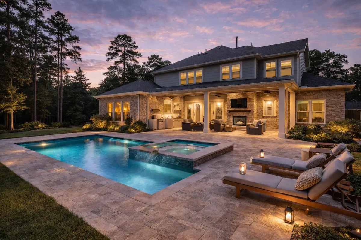
A large property can look flat if the angles are wrong. At 30 to 60 feet, you preserve landscaping depth while still showing the home’s facade. At 120 to 200 feet, you reveal lot shape, setbacks, and surrounding canopy without turning the home into a dot. Bayou adjacency is best shown on a shallow diagonal that includes both the water and the terrace line, so buyers understand why sunsets behave the way they do. Tennis courts and motor courts benefit from a slight tilt, not a high vertical. Pools and water features need a polarizer to cut glare and show tile color. On humid summer days, haze at higher altitude softens the scene, so we stage hero shots lower and reserve the high views for context.
We also watch the horizon line. Houston is famously flat, which means a crooked horizon is glaring. Gimbal calibration and a two point alignment check before takeoff keep verticals clean. Where mature oaks frame a facade, we fly with gentle forward motion and a slow gimbal tilt to keep the foliage moving past the lens, adding depth without distracting from the stonework.
Airspace and approvals, the Houston specifics
Drone rules are national under FAA Part 107, but Houston brings its own map. You have two Class B spheres to consider, around George Bush Intercontinental and William P. Hobby. Portions of inside the Loop fall under controlled shelves that require LAANC authorization for even modest heights. Golf course communities near Spring and Cypress sometimes clip the edges of controlled grids as well. We handle LAANC requests in minutes when the grid permits, and for trickier locations we arrange schedule windows that avoid peak tower loads. Temporary Flight Restrictions can pop up for stadium events or VIP movement across the city. We always check TFRs the morning of a shoot and again an hour before liftoff.
Beyond the FAA, private estates live inside layers of community rules. HOAs in Memorial Villages, Carlton Woods, or Royal Oaks can restrict flight times or overflight paths. We obtain written acknowledgment from the HOA or security office when needed. For river frontage, we keep line of sight rigidly maintained. The bayou corridor may look like an open ribbon, but you share that air with hobby pilots and birds. We plan flight boxes that remain inside the client’s property boundary unless the listing demands a neighborhood context shot, and we secure neighbor permissions ahead of time when we intend to show cul de sac flow.
Discretion first, always
High net worth sellers expect quiet operations. That starts with planning, not just equipment. We arrive in unmarked vehicles on request. We keep crew size narrow. We brief the listing agent on likely vantage points so there are no surprises for household staff. If the property has an NDA, we bind to it and treat all raw imagery as confidential work product. File handling is disciplined: encrypted cards on set, checksum verification during ingest, and private galleries for review. On lake houses and compounds with guest residences, we avoid windows and sight lines that could reveal family life. Drone work makes it easy to overshare. We would rather deliver fewer frames and preserve comfort.
Light, heat, and the way Houston breathes
There is a good reason sunrise is prized in August. Wind is calmer, heat shimmer has not yet started, and cicadas have not found their full voice. Golden hour gives the limestone a soft face, and the pool reads like glass instead of a mirror. For north facing facades with deep porches, afternoon light can flatten the columns. We shift to a slightly elevated angle that lets sunlight rake across texture. When humidity is thick and clouds are high, we lean on a touch of negative exposure compensation and gentle curve work in post to bring back contrast without making the lawn electric green.
Wind is often layered. At ground level you feel a breeze, but at 150 feet the tree tops tell a different story. We perform a two height wind check before committing to long tracking shots, especially over water. Summer thermals mean that midday orbits can bump the gimbal. If the schedule demands it, we cut flight speed and increase radius to smooth motion. The trade off is a wider arc, so we clear more perimeter for safety.
Image discipline that sells the estate, not the drone
Drone footage is a tool, not the show. Buyers want to understand flow. That means starting wide to set the stage, moving to medium frames that explain the drive and entry sequence, then finishing with details that belong in the ground set. On stills, we keep verticals true and avoid barrel distortion. On video, we favor parallax. A slow orbit with a concurrent gimbal tilt gives the main house authority while the grounds reveal themselves. When we need drama, a gentle pullback that starts close to the loggia and retreats to show the full pool terrace reads as generous, not gimmicky.
Water color is a constant battle. Houston light bounces off beige stone and can leave the pool cyan. A circular polarizer helps, and we meter for the highlights on the water first, raising shadows in post. For copper roofs and metal cupolas, a slightly warmer white balance preserves tone and avoids the greenish cast that can creep in with heavy foliage nearby.
The kit we trust and why it matters
Quiet aircraft make good neighbors. We choose drones with low acoustic signatures and a neutral color profile that grades well alongside ground cameras. We fly with ND filters to hold 1 over 60 or 1 over 120 shutter for motion cadence and use polarizers near water and on glossy pavers. Redundancy is non negotiable. Two aircraft, multiple batteries, independent controllers. Houston heat punishes LiPos. We rotate batteries, cool them in insulated cases, and never charge inside a vehicle. For on site calibration, we verify compass and IMU away from rebar heavy driveways which can throw sensors. We maintain waivers and currency for night operations when twilight sequences are essential.
Safety and insurance, the quiet backbone
We carry aviation liability tailored for unmanned operations, and we provide certificates to brokers or owners on request. Before flight, we walk the property with the agent or manager, calling out line hazards like pergola wires or patio heaters that do not show in a satellite map. We establish takeoff and landing pads on firm, level ground, away from gravel that can kick into the props. If pets will be outside, we coordinate their movement. Horses and drones do not mix, so on equestrian properties we only fly near the arena with handlers present and the animals stabled.
The risk Luminis Media real estate photography that gets overlooked is data risk. A crashed drone is expensive. A leaked floor plan or pool layout can be worse. Our crews are trained to refuse curiosities, like peeking into a neighbor’s courtyard for a “bonus angle.” We keep it disciplined and predictable, which is the only way to build trust with communities that remember every vendor.
Storytelling with motion, restrained and purposeful
Real estate videography is strongest when it mirrors how a buyer will experience the estate. A typical structure starts curbside, follows the motor court, pauses on the entry axis, then lifts to show how the house sits on land. Interior scenes carry the narrative, then the drone returns for twilight, when the landscape lighting ties everything together. Hyperlapse has its place, especially with downtown skyline views that sellers want acknowledged. Used sparingly, a rising time shift from the backyard to the city glow places the home properly on the map.
Music selection influences motion profile. We edit drone cadence to match the piece. If the score is spacious, holds can be longer and reveals slower. For social cuts, we reformat to vertical and adjust composition so the home remains central, avoiding the common error of cropping out the best parts of the frame. This is where luminis.media real estate videography earns its keep, translating one master sequence into MLS safe, YouTube long form, and Instagram verticals without feeling like three diluted versions of the same thing.
Working with water, woods, and acreage
Houston’s estates often touch water, even if only a retention lake done handsomely. Wind across water introduces micro ripples that vibrate in the frame at certain shutter speeds. We test early, then adjust. Bayou lots carry mature canopy that hides parts of the facade. Rather than forcing a top down, we find the gaps and fly channels, letting the trees act like curtains that open. On acreage, topography is subtle, so shadow is your friend. Morning or evening, low sun throws contour on lawn and pasture. To show property lines truthfully, we do not invent boundaries with graphics unless the seller has a survey on hand. When a fence line is deep and crooked, a conservative label keeps expectations right.
For equestrian elements, viewers need scale. The best move is a slow lateral that travels the long side of the arena with the gimbal locked level, which explains dimensions cleanly. For barns, we avoid roof shots that feel like inspections unless the seller is highlighting new construction. Else, keep the camera at eye height and use the drone like a jib, rising just enough to show aisle flow.
Deliverables, formats, and how they integrate with MLS
The MLS has expectations. Photos must be clear, undistorted, and free of branding. Video links must behave across devices. We build a deliverable set that gives agents options without clutter:
- Aerial stills in both print ready resolution and MLS optimized sizes, color matched to the ground set.
- A master video in horizontal, with optional clean version for brokerage rules, plus vertical edits for social distribution.
- A neighborhood context package when the listing needs schools, parks, or golf course proximity explained in a compliant way.
- Ground to air continuity shots so the transition in the property film feels intentional, not like a helicopter cutaway.
- A short loop of the hero angle for listing portals that auto play silent clips.
Agents who already rely on Luminis Media listing photography find that aerials slide into their existing visual style, which matters for brand consistency across multiple high end listings. When requested, we provide luminis.media MLS photography as a single booking so scheduling and color science line up.
A quiet checklist that keeps the day smooth
When properties are large and calendars tight, clarity helps. This is the planning sheet we review with the agent the day before:
- Confirm HOA or security gate notifications, plus any staff schedules that affect access.
- Approve the shot map, including exact context frames that may capture neighbor properties.
- Check LAANC, TFRs, and weather windows, then lock sunrise and twilight holds.
- Align on staging details that matter from the air, like umbrellas, cushions, and driveway parking.
- Set delivery timeline and format needs, including MLS caps, social cuts, and any brokerage specific restrictions.
That agreement prevents the common time sink, which is remounting to chase a missing car or a closed umbrella. The drone sees more than the eye, so small items matter.
Pricing and scheduling realities without the fluff
Every estate is different. A one acre lot with a straight facade and easy light can be photographed in a tight window. A six acre compound with water, guest houses, and a tennis court needs more time, especially if we want to catch morning and twilight in a single day. We quote based on scope, with packages that combine aerials, ground stills, and motion to keep total cost reasonable. Some shoots benefit from splitting over two days, which lets us chase ideal light both east and west. We are transparent about add ons, like night operations or advanced editing for heavy haze days. Clients who partner with Luminis Media aerial real estate photography repeatedly see that careful planning beats throwing more flight time at a problem.
Post production that respects restrained color and honest scale
Houston greens can turn neon if pushed. We keep lawns natural, warming the highlights and holding saturation in check. Roofs get a careful hand, particularly clay tile. On water, we use selective saturation to keep the pool inviting without washing out spillways. For stills, professional real estate photography Luminis Media we blend exposures modestly to balance porch shade and sunlit turf. The goal is dynamic range that looks like a well exposed photograph, not a composite. For video, we grade drone and ground footage in the same color space so transitions feel seamless. Speed ramps are subtle, used only where movement calls for emphasis, like a reveal from behind the loggia to the full terrace.
Metadata matters for MLS. We strip creator tags where required and deliver clean files. For agents who need branded sets for their own channels, we prepare parallel exports. This is also where MLS photography Luminis Media workflows shine. Consistency saves hours when listings stack up in peak season.
A brief case note, River Oaks at sunrise
A recent River Oaks property sat under a canopy of oaks with a long, curved motor court. The seller wanted to show how cars circulate without cluttering the facade. We scheduled a sunrise flight when the drive was clear, staged one vehicle at the far end for scale, and flew a low diagonal that traced the curve while the gimbal eased up to place the home in frame. The second move lifted to 120 feet, catching a thin band of fog above the bayou, proof of the microclimate that keeps the lawn green. From that vantage, downtown peeked over the trees. We included a soft focus skyline at the far left edge, a nod to proximity without making the house feel small. Ground stills followed, and twilight returned us to the loggia glow. The final film ran under two minutes. It felt unrushed and complete.
How we integrate with your existing media stack
Many brokerages already have preferred shooters for interiors. Our role is to extend that language to the air. When we deliver luminis.media aerial real estate photography in tandem with a ground team, we coordinate color charts and lens choices so facade tonality and stone read the same in both sets. For teams that rely on Luminis Media MLS photography end to end, we plan the sequence as one story. The drone does not arrive to grab a reel. It participates in a day designed to support the listing strategy.
If your campaign includes paid social, we produce additional vertical assets tailored to the platform. Instagram demands opening motion in the first second. We build a reveal that starts informative and beautiful, not just loud. YouTube prefers slightly longer sequences, where we can show a second or third angle. For property websites, we embed royalty safe music and provide clean caption files, which helps with accessibility and SEO.
Legal use, licensing, and long tail value
Imagery has a life beyond the first listing. Builders and architects often ask to reuse frames for their portfolios, particularly when the house sells quickly. Our agreements specify who can use the imagery and for how long. For agent teams, we offer extended licenses that cover re marketing and case studies. We also create archival edits, including a clean, no agent branding version that can be reactivated if the home returns to market. This structure respects the seller, the builder, and the agent’s investment.
When to use aerials sparingly
Not every property benefits from a long aerial sequence. If the estate is primarily an interior jewel with limited grounds, a handful of exterior frames may be all you need. A top down of a small lot can make it feel smaller. In those cases, we keep the drone low and let the ground set do the heavy lifting. The value of luminis.media drone real estate photography lies in judgment more than in flying. Knowing when to hold the shot on a quiet cypress reflection is as important as knowing when to climb.
Ground and air, a compact comparison of roles
Choosing the right tool for each moment keeps the story clear:
- Ground stills carry material detail, texture, and the human scale of entry and rooms.
- Low altitude drone shots explain flow, driveway geometry, and pool to porch relationships.
- Mid altitude angles describe lot shape, tree canopy, and privacy from the street.
- High altitude context frames locate the estate relative to parks, bayous, and skyline.
- Motion from either platform ties the narrative together, with the drone providing clean moves that would be impractical with cranes.
Booking and cadence that respect the market’s tempo
Houston listings move on weather and school calendars. Spring is brisk. Late summer can be unpredictable with storms and heat. We hold optional weather windows at no extra fee within a reasonable range, because forcing a shoot into a thunderhead serves no one. Twilight slots are limited. When agents lock those early, the rest of the day falls into place. Our team communicates honestly about what the light will offer on a given date. If a forecast shifts, we pivot. Sellers appreciate not having their day disrupted for images that lack the polish the home deserves.
The fit for your next listing
Private estates need more than a drone pilot. They need a quiet partner who understands gates, staff, airspace, and the unwritten rules of Houston’s grand neighborhoods. Luminis Media drone real estate photography is shaped by that culture. We take the time, we bring the right kit, and we edit with a restrained hand. If you already rely on Luminis Media listing photography for interiors, adding aerials keeps your brand consistent. If your priority is MLS compliance with strong impact, luminis.media MLS photography and aerial packages cover that without noise. And if motion is the centerpiece of your campaign, our real estate videography luminis.media team will write a visual story that respects the property and the viewer, frame by frame.
When the aircraft lifts and the house settles into the frame, the job is simple. Tell the truth about the land and the life it offers. Everything else is logistics, judgment, and the patience to wait for the right moment of light.